|
|
Post by theomen on Apr 2, 2016 21:10:43 GMT
Just a quick question about navionics as I've got cmaps at the moment so don't know how the sonar logging etc works.
Basically if I bought the gold card, could I sonar log a lake that hasn't been charted or can I only chart areas that have the base map ie at sea? I tried to find an answer online but couldn't find anything but thought you guys might know.
Thanks
|
|
|
|
Post by Izzetafox on Apr 3, 2016 9:06:25 GMT
Not sure what ff you are using mate but there are various options. A program called Reefmaster can take you 'track files' and convert them into depth charts. I believe the Nations package has a similar online facility. Garmin are set to introduce a similar on line mapping facility. The set up a few of us are using now is based on Lowrance fish finders. I save my log files and load them up to www.gofreeshop.comThis then merges them with previously uploaded files from others and makes the map available to all. There is a rapidly growing library of freshwater venues. The map file can then be downloaded to any Lowrance setup with mapping and you can use it on the water. This is a section of Pitsford Reservoir. Terry 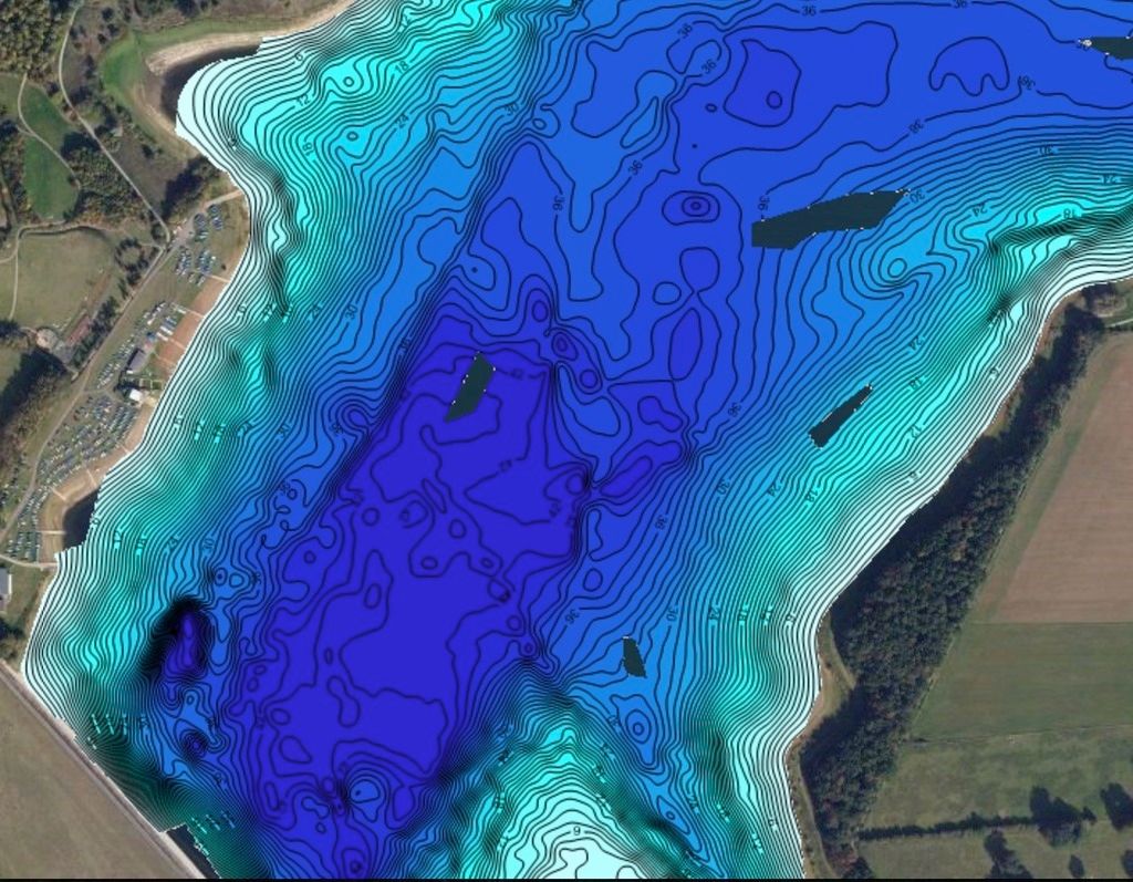 |
|
|
|
Post by theomen on Apr 3, 2016 11:08:23 GMT
I'm after a new combo unit with side scan/imaging and after a quick look around I liked the hummingbird helix 7 until I saw with humminbird the software to write your own charts is 200 where it's free with the lowrance units. I then looked at the lowrance hds7 gen 3 which looked great then I noticed it's another £200 for the transducer that allows you to use the technology your paying for and I was hoping not to have to break the £1k barrier.
Going to look at garmin units later and see what there equivalent is. Nightmare this electronics business!
|
|
|
|
Post by jonahjones on Apr 3, 2016 11:25:01 GMT
Hi Shaun I would also ask the question on the Pikers Pit. There is a lot of expertise on there regards high end finders in the Boat fishing section. Three people in particular, Ian Crook, Jon Shoreman and Martyn Cattermole are very knowledgable. Terry, I hope you don't mind me passing on the link. www.the-pikers-pit.co.ukRegards Jonah |
|
|
|
Post by Izzetafox on Apr 3, 2016 12:31:35 GMT
Of course not, as you know I go there myself.  Anything that helps people out is welcomed. Terry |
|
|
|
Post by jonahjones on Apr 3, 2016 18:52:51 GMT
Thanks Terry
I thought it best to ask.
|
|
|
|
Post by theomen on Apr 3, 2016 19:47:39 GMT
Signed up to that piker pit thanks for the link I Spent all day reading about units and watching videos about units, charting etc on YouTube. I'm going for the lowrance elite 7 si with total scan transducer. Not heard anything good about writing your own charts with humminbird units either with their own software or third party. The lowrance HDI 7 gen 3 was great but I would be breaking my budget for a lot of features I wouldn't use and it also uses 2 transducers. The Lowrance Elite 7 SI meets my criteria entirely and well if old buggers like Terry can work insight Genesis then I'm sure I'll be just fine haha Thanks for the input gents |
|
|
|
Post by Izzetafox on Apr 3, 2016 21:00:11 GMT
Insight is dead easy Shaun. Did you register so that you can explore the "Social Maps"? The range is expanding all the time. I use it at Pitsford and it lets me follow contour lines or a shelf, I can see ahead on the map so much easier to plot a course when trolling and avoiding shallow bars etc. The great thing is the mapping is increasing all the time and the more people that cover the same water the better defined the maps become. If you are going to Esthwaite then there is fantastic mapping from there that will stop you paddling a mile only to find the bay you thought would be good is only 12" deep. I have the 7 Elite Chirp and I am very happy. The extra size on the screen really improves things. Terry |
|
|
|
Post by theomen on Apr 3, 2016 22:05:46 GMT
Yes Terry it all looks great and I'm excited about having ago The screen size is going to be a big step up from my dragonfly 4! |
|
|
|
Post by Izzetafox on Apr 4, 2016 8:30:10 GMT
Just be careful when handling them. The 7 range have glass screens. I dropped mine and the screen caught a hard surface and I now have three cracks. It still works perfectly. I should add it is not a flaw in the unit, in normal use glass is better than plastic as it is more durable. It's just when it gets in the hands of a fumbling idiot like me !! |
|
|
|
Post by theomen on Apr 4, 2016 20:46:52 GMT
I did see it had a glass screen, don't recall dropping any of my fish finders but there's always time for a first. My next fibre glass project will be to make a shade for it when it comes so I might make a wrap around one with a small gap between the unit and fix it in place with double sided rubberised gasket tape to absorb impact if it turns out ok I'll knock you one up haha.
|
|
|
|
Post by Izzetafox on Apr 4, 2016 20:57:02 GMT
There are screw holes in the back of the unit that can be used.. I have NOW fitted a screen shade from Berleypro 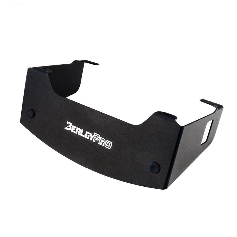 |
|
|
|
Post by theomen on Apr 4, 2016 21:36:05 GMT
Good stuff, just ordered one, saves me faffing about |
|
|
|
Post by Izzetafox on Jun 8, 2016 16:42:00 GMT
Back to the mapping sidw of things.....I have been using the Vexilar Sonarphone T-Box 200. It is a transducer with a small box. This then connects to your phone or tablet by wifi. Then you have the Navionics app connected and as you paddle you scan the depths, they save to your app and can be uploaded to the Navionics web site. In a short time the data will be available to all Navionics users. It is a more public way of sharing freshwater mapping. 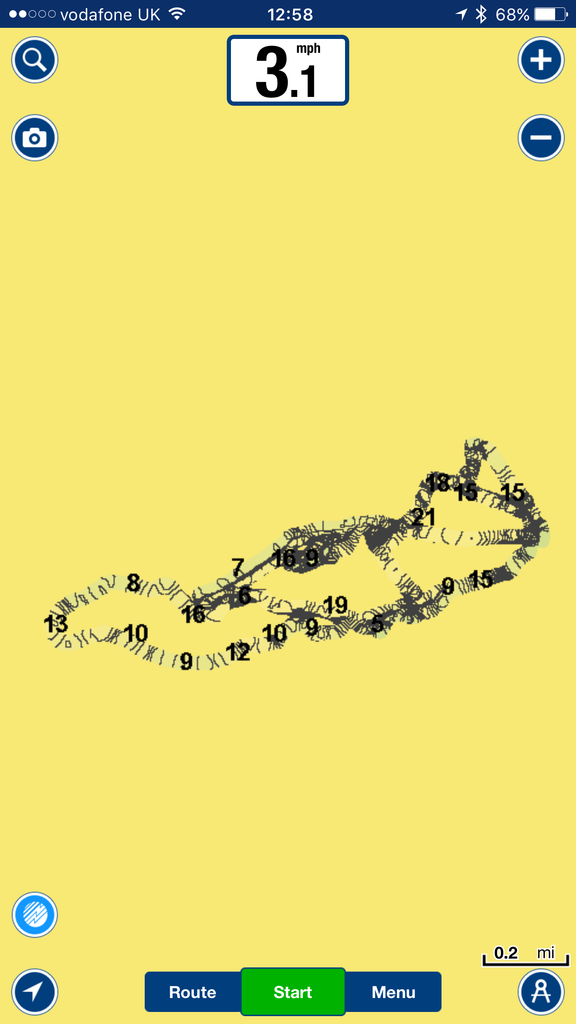 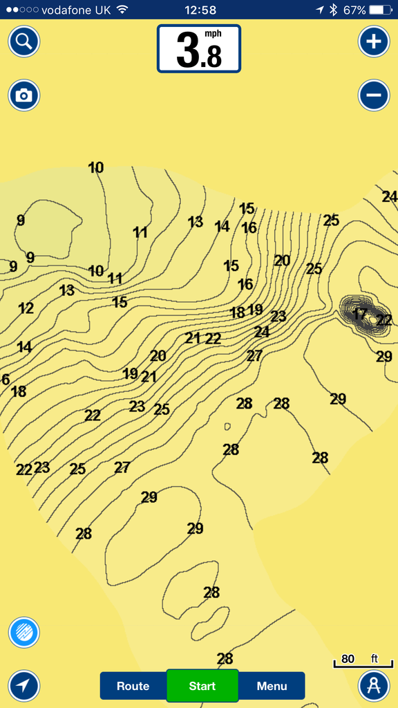 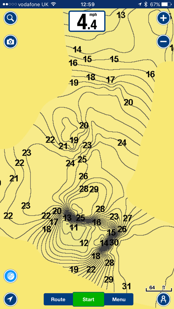 |
|